


Before we dive deep into the latest information on Ida, we'll briefly mention what we can expect here at home over the next 24-48 hours. A few showers and one or two isolated thunderstorms will remain possible through sunset this evening before lingering activity tapers off. It will be quiet overnight with lows in the mid 70s. The same storyline continues Sunday with highs near 90 and a few afternoon thunderstorms, mainly confined to areas west of I-65.
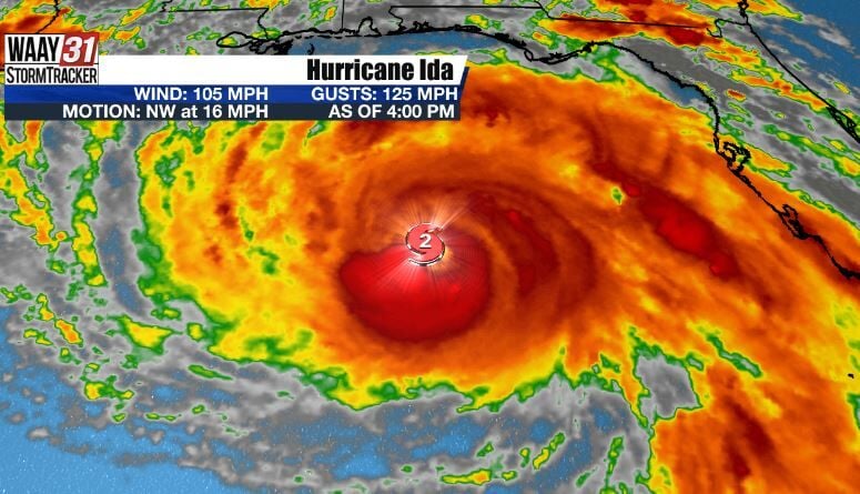
Now onto Ida. A very concerning situation continues to unfold. As of 4 PM, Ida is now a Category 2 hurricane with sustained winds of 105 MPH. Rapid intensification is in progress, meaning the sustained winds of Ida will increase at least 35 MPH in a 24 hour span (Ida will certainly strengthen quicker than that).Â

We expect Ida to reach major hurricane strength later this evening with projected landfall near New Orleans Sunday afternoon as a Category 4 storm. It goes without saying, but Hurricane Warnings are in effect for much of Louisiana. Tropical Storm Warnings stretch all the way to Mobile and Gulf Shores. Storm surge of 10-15 feet will be possible in Louisiana, with 15-20 inches of rain also expected.

The overall forecast track of Ida has not changed. Ida will hook back to the northeast Monday and into Monday night, with the center of the storm located in northern Mississippi Tuesday morning.

This particular location means two things for North Alabama: a higher risk for heavy rain and flash flooding and a high risk for spin up tornadoes. We could begin to see outer bands of what is left of Ida as early as Monday evening. The best chance to see heavy rain and severe storms will be after midnight Monday night through the entire day Tuesday. With any of these bands that develop, heavy rain and tornadoes will be possible. Currently, the heaviest rain is expected closer to the center of Ida in northwest Alabama, where 3 to 5 inches of rain are currently forecast. Expect lower, but still significant, amounts of rain the further east you go. The I-65 corridor is currently forecast for 2-4 inches of rain, while Sand Mountain can expect 1-3 inches. The worst of Ida begins to move out Tuesday evening, but a few residual showers will be possible Wednesday (especially during the first half of the day).

Keep in mind that this forecast can and likely will change. Any shift in the exact center of Ida's track could lead to significant changes in our forecast. A further west track could mean less rain and maybe a slightly lower tornado threat. A further east track could mean less of a tornado threat, but a more significant flooding threat. We won't be able to iron out those details for certain until we see Ida making landfall and moving inland. We will continue to fine tune the forecast and pass along updates as we get them. Stay with Â鶹Çř on air and online at for continuing updates.


