

*Wind Advisory in effect until 3 PM today*
Widespread rain is moving out of North Alabama this morning. Roads remain wet and visibility is reduced in many locations. Plan on an extra 10 to 15 minutes getting to work or school.
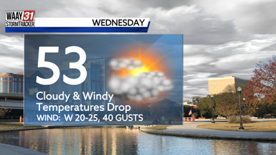
Temperatures drop throughout the day following the passage of a cold front. After starting this morning near 50 degrees, we will fall into the 40s by the afternoon hours. Wind gusts up to 40 MPH remain possible today, which is still enough to toss around loose objects and cause isolated power outages.
Light scattered showers will redevelop this evening lasting through Thursday morning. Most of this will just fall as cold rain, but the higher elevations of northeast Alabama and southern Tennessee could see some wet snowflakes. Any accumulations would only amount to a dusting on elevated surfaces.
Thursday will be cold and cloudy with highs in the 40s and lows in the 20s. Sunshine and 50s return Friday and Saturday.
WEDNESDAY: Mostly cloudy. Windy. Scattered evening showers. Temperatures falling into the 40s. Chance of rain: 30%. Wind: SW 20-25 MPH, gusting up to 40 MPH.
TONIGHT: Scattered showers. Wintry mix possible in the higher elevations. Lows in the mid 30s. Chance of rain: 20%. Wind: W 15-20 MPH, gusting to 30 MPH.