

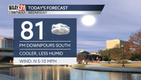


Wednesday will be the most comfortable day of the work-week so far with high temperatures much closer to average in the low 80s today. Dew point humidity levels are much lower today, as well.

Scattered showers will be moving through this afternoon but the Valley should be dry by early evening. Any showers in the area will bring heavy rain and periods of gusty wind but will be short lived.

Thursday brings breakfast time light rain that will turn to slightly heavier and more widespread showers by the afternoon that will last through dinner. High temperatures will sit near 80s degrees with a gusty breeze. Some isolated showers will stay in the forecast overnight but very few of us will actually see the rain.
Friday brings some breakfast time light rain but that clear out of our system quickly and will allow for a dry but mostly cloudy afternoon. Heavier storms, widespread in nature, will return to the forecast in the overnight hours and last throughout about lunchtime on Saturday.
Both Friday and Saturday will feature high temperatures in the upper 70s.
Sunday through much of the rest of the work-week will be mostly sunny and dry with temperatures gradually rising from the low 80s on Sunday to the upper 80s on Friday.
WEDNESDAY: Mostly cloudy. Spotty showers and storms south of the Tennessee River. Highs in the low 80s. Chance of rain: 20%. Wind: NNE 5-10 MPH.
TONIGHT: Mostly cloudy. Lows near 60. Wind: NE 5 MPH.


