

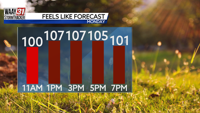

The heat continues to build in and become more dangerous across North Alabama today. It is already very warm and muggy this morning with temperatures in the mid 70s. A Heat Advisory is in effect for northwest Alabama and the I-65 corridor from noon to 6 PM today for heat index values at or above 105 degrees. Actual air temperatures will reach the upper 90s with the heat index peaking between 103 and 107 degrees in the Advisory area. Even areas not in the Advisory (Sand Mountain) could see the heat index peak between 99 and 103 degrees this afternoon. Stay hydrated, stay cool, and take frequent breaks indoors if you will be outside during the peak heat today. There will be little in the way of relief today as skies stay mostly sunny with no rain chances. Overnight lows are still quite warm in the mid 70s.
The heat and humidity are not going anywhere. Highs remain in the mid 90s all week. Heat index values each afternoon will hover near the 100 degree mark. While it will stay hot, it may not be as dangerously hot past today. Even so, exercise caution if outside throughout the week. Starting Tuesday, small chances for isolated showers and storms are back in the forecast each afternoon. Not everyone will see storms, but those who do could see gusty winds and very heavy rain.
A cold front may bring some relief in the heat by the weekend. Highs will remain in the low 90s Saturday and Sunday though, but slightly less humidity will make for a more tolerable weekend. Long-term forecasts suggest highs may stay in the mid 90s through the end of June.


