
A few evening storms

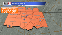
**HEAT ADVISORY FROM NOON WEDNESDAY TO 7PM THURSDAY**
Hot and humid conditions will persist through the end of the week. A combination of highs in the mid 90s and high humidity will push the Heat Index over 105 at times. Rain chances will continue to fade across the area for the next couple of days.
Tonight bring a chance for some showers and storms through the evening. Lows will be in the mid 70s.
Expect a partly cloudy, hot and humid Wednesday. Afternoon highs will reach the mid 90s. We will likely stay dry. Thursday brings pretty much the same.
An approaching cold front Friday could bring an isolated rain chance, otherwise look for another hot and humid day.
A stray shower or storm is possible Saturday, but Sunday is looking dry. Temperatures will ease back slightly over the weekend into the low 90s with just a touch less humidity.
TONIGHT: Isolated showers and storms. Lows in the the mid-70s. Wind: Light S. Chance of rain: 30%.Â
WEDNESDAY: Partly cloudy, hot and humid. Highs in the mid-90s. Wind: S 4-8 mph.