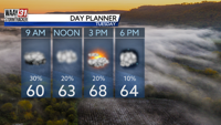

Take it slow on your morning drive. Roads are wet as rain continues to move out of North Alabama. Lingering showers taper off by midday, setting the stage for a dry and very warm afternoon. High temperatures reach the upper 60s.
The break in the rain will be rather brief. Spotty showers return Wednesday in advance of a cold front that sweeps through the region Wednesday night. Some storms could be strong to severe with damaging wind gusts being the main threat. Storms come to an end by sunrise Thursday.
Temperatures remain well above average through Thursday with highs approaching 70 and lows in the 50s. Cooler air returns Friday, dropping our highs back into the 50s. Another system looks to bring widespread rain back to North Alabama Saturday night and Sunday.
TUESDAY: Lingering showers through midday. Mostly cloudy and warm. Highs in the upper 60s. Chance of rain: 40%. Wind: SW 5-10 MPH.
TONIGHT: Mostly cloudy. Lows in the mid 50s. Wind: SE 5-10 MPH.