

Weather 04/27/22
Tonight, temperatures drop back into the mid- to upper 40s with a few passing clouds.
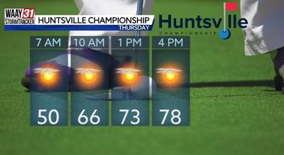
We'll see the return of the 80s Thursday! Highs during the afternoon will hover right around the 80-degree mark, and it'll even be a smidge warmer Friday. Meantime, expect a mostly sunny sky Thursday with clouds increasing to end the week.
As moisture increases, isolated showers and storms are possible Friday and Saturday, then better rain chances arrive with a weakening cold front Saturday night into Sunday. After some morning showers and storms, we may even have some pop-up storms Sunday afternoon. There will be no appreciable drop in temperatures as the cold front continues to weaken over the area.
The weather early next week will be reminiscent of a summertime pattern, with warm temperatures and afternoon pop-up storms. Any stronger storms will be capable of producing gusty wind, but there's currently no outlined risk for severe weather for North Alabama.