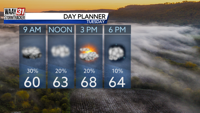
Today's gusty winds will gradually weaken overnight as our latest system clears to the east. We'll see mostly clear skies tonight and lows in the upper 40s.
Tuesday looks just about perfect, with plenty of sunshine, light winds and highs in the mid-70s.
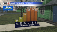
The pattern turns stormy for the tail end of the workweek. Scattered showers and storms may start as soon as Wednesday afternoon, but they look more likely to occur Wednesday night. A severe storm or two will be possible, but heavy rain looks like the primary concern, especially near the Tennessee state line.
Additional scattered showers and storms are expected Thursday into Thursday night. A strong cold front will arrive early Friday, posing the biggest threat for severe weather. Damaging wind gusts will be the main threat, though tornadoes can't be ruled out.
Highs late this week will go from the upper 60s and low 70s on Thursday and Friday to near 60 this weekend.
TONIGHT: Clearing skies. Calming winds. Lows in the upper 40s. Wind: SW 5-15 MPH.
TUESDAY: Mostly sunny. Highs in the mid-70s. Wind: SW 3-8 MPH.